|
Wahclella
Falls Loop Trip
|
|
Trip Date: 06/22/2015
Distance: 2.2 Miles
Vertical Gain:
350'
Group Size:
40
Hike Rating: Easy
Moderate
Hard
Strenuous |
GPX for
this trip
|
|
Start Coordinates: |
N 45 38.104, W 121 57.207 |
|
End Coordinates: |
Same as starting coordinates |
Car Shuttle
Req'd: |
No |
|
Parking
Directions: |
Take Interstate 84 from
Portland into the Columbia River Gorge. Take Exit 40
(Bonneville Dam) and turn right at the road for a small parking area.
If this is full, head back under the freeway into the parking
area for the Bonneville Dam and park at the posted
coordinates. |
Hazards of
Note: |
The trail can be slippery when
wet. |
|
Crowd Factor: |
Moderate. This is a
lesser known destination than Multinomah Falls a few miles west on the
same highway, but can see a number of visitors especially on weekends. |
General Notes:
From the parking area, you will find a well-marked trail to Wahclella
Falls along a gravelly road right from the start. You will
almost immediately pass a power structure on the right with a small
diversion dam, and then the trail will begin to gradually head up and
into the green surroundings of the trees and vegetation.
About 1/4 mile along the trail you will cross over a wooden
bridge, with an unnamed waterfall glissading down on your left over a
rocks and running below the bridge. Continue another 1/2 mile
and you will get to an intersection where you can either head up to
your left, or down to the right. Both of these paths will
take you to the falls, but you can approach either from above and drop
down (the path on the left) or head up the stream to the falls pool
(the path on the right.) After enjoying the falls
continue back the way you didn't take on the trip in to make it a bit
of a circle path rather than a straight out and back.
|
|
|
The two signs you will pass on
the way to the trailhead near the parking area. |
|
|
The bridge early on that
passes over the first, unnamed falls on the way.
|
|
|
A couple of the chaperones
heading on up the very cool, green trail. |
|
|
Mossy trees along the way,
looking much different from those we see on the drier California trails. |
|
|
A little over halfway along
the trip you can either head up to the left, or down to the right.
Both paths take you to the same place but up this way you get
a great view of the falls from above first. |
|
|
Bringing 45 hikers on a single
track trail is bound to cause a few traffic jams, and the noise also
keeps the bears, lions, and tigers away. |
|
|
At one point along the upper
trail you could look down and see the way we would be coming back on
the lower trail alongside the stream below the falls. |
|
|
The first look you get of
Wahclella Falls as you arrive at the upper viewpoint. |
|
|
Some of the coaches enjoying
the view of the falls from the higher overlook spot. |
|
|
The players posed in front of
the falls at the upper overlook spot. |
|
|
The group making its way down
to the waterfall pool. |
|
|
The players posed in front of
the falls at the upper overlook spot. |
|
|
A good shot of the perspective
of how large the falls really are. |
|
|
Going out on a limb for the
team. |
|
|
My wife and kids along with me
on the trek. |
|
|
The first view of the falls
that you will have coming in on the lower trail. |
|
|
Checking out a water-carved
cavern on the lower trail portion of the hike. |
|
|
The players posed in front of
the falls at the upper overlook spot. |
|
|
A look at the river that
crosses under the last bridge where it flows after coming down the
falls. |
|
|
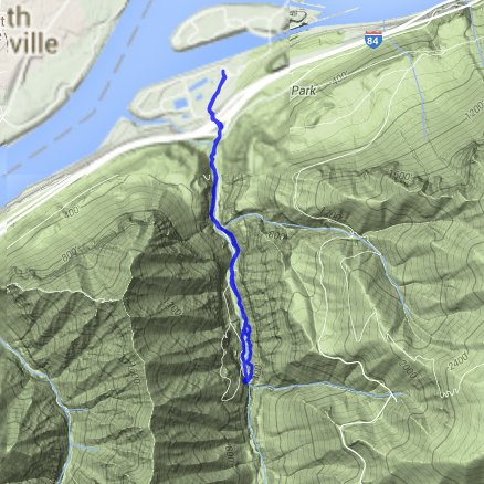
GPS track of the hike starting
at the bottom right. |
|