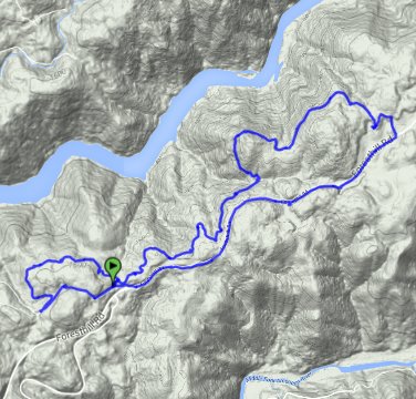
Distance: 7.2 Miles
Vertical Gain: 300'
Group Size: 3
Hike Rating: Easy Moderate Hard Strenuous

 GPX
for
this trip

| Start Coordinates: | N 38 56.122 W 121 00.256 | End Coordinates: | N 38 56.556 W 120 58.953 if deciding to do a car shuttle trip | ||
| Car Shuttle Req'd: | Yes or No | Parking Directions: | Take Highway 80 to Foresthill Drive and head east for 3 1/4 miles. Turn left on Lake Clementine Drive, and find the small parking area less than a half mile up the road on the right hand side. You can continue up the road another 1/2 mile to the trailhead parking, but there is less space there for cars or trucks to park. If making this a car shuttle trip, continue two miles up Foresthill Drive to the end parking coordinates on the right hand side of the road. This parking area now (as of 2015) had a fee for day use of $10. | ||
| Hazards of Note: | Rattlesnakes, ticks, poison oak, mountain lions. | Crowd Factor: | Moderate. This is a very popular trail for mountain biking, and on a middle of the week day we were passed by 12-15 mountain bikers on the trail. | ||
| General Notes: From the parking area head north on the small single-track dirt trail, and then within a quarter mile you will hit a junction left or right. We went left, and followed this part of the trail out to the Lake Clementine Road after about a mile. This is actually the trailhead for the connector trail when you get to the paved roadway. Follow the road back to the parking area, take the same single track trail and then turn right at the junction for the main part of the trail. Most of this trail is hard-packed from many mountain bikes travelling along it, but easy elevation with little gain or loss along the way, and some interesting plants and trees keeping you shaded for much of the trip. About a mile this direction you will pass through a pleasant grove of madrone trees, and then after about 2 miles you will finally get to some sections with that have expansive views of the north fork of the American River and Lake Clementine far below. Cross a wooden bridge and the trail then heads north, coming out of the tree cover to wind around a small hill. At the north end of this hill is a spectacular view down into the canyon, both to the east and to the west. Continue on this trail as it then wraps around to the south, eventually coming to a place where there is a four way trail junction. Continue straight on the trail you were on (to the south) and this will take you back to Foresthill Road for your completion of the trip, either by car parked at this end or by walking carefully along the road the two miles back to the original parking area. |
|||||
