Back to index Bennettville Ghost Town Hike
Trip Date:  07/17/2015

Distance
: 2.0 Miles

Vertical Gain: 300'

Group Size: 1
Hike Rating:  Easy   Moderate    Hard   Strenuous
Bennettville Hike
Download GPX GPX for this trip
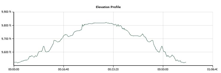
Bennettville Elevation Profile
Start Coordinates:   N 37 56.312, W 119 15.024     End Coordinates:   Same as Start Coordinates

Car Shuttle Req'd:   No Parking Directions:   From Highway 395 turn west toward the Yosemite park entrance on the eastern side of the park.  Follow Highway 120 (Tioga Pass Road) approximately 8 miles and turn right on Saddlebag Lake Road.  Take an almost immediate left at the fork toward Junction Campground, and park at the coordinates provided near a small plaque giving the history of the town of Bennettville.  If these spaces are full, turn around and park along the road between here and Highway 120.
Hazards of Note:   Some elevation gain, mosquitos. Crowd Factor:   Minimal.  This is a lightly used trail to Bennettville, although it is used for access into the lakes area in the Hall Research Area a couple miles to the north.
General Notes:
Head across the small bridge from the parking area toward Junction Campground, and then turn right at the kiosk and the sign with the slightly misspelled name of the ghost town (missing a "T".)  You will head along the creek for a few hundred feet, and then the trail to Bennettville actually makes a sharp left and heads upwards a little bit as opposed to the use trail which continues along the creek.  There is a sign here, but be careful not to miss it.  
The trail will continue to meander a little bit above the Junction Campground sites, and then head further up along another river with a number of small cascades visible along the way.  After a mile you will see the two remaining (restored) buildings from the Bennettville town, the Assayers office and a Barn.  There is a small plaque below the barn as you make your way up, and there is information posted on the buildings about the history of each of them.


Be sure to check out this information plaque regarding the history of this town, as it was instrumental in developing Tioga Pass Road, what you used to get to this starting point. Info Plaque
Although it is slightly misspelled on this sign, just across the bridge from the parking area is the start of the trail to the ghost town.
Trailhead
The beginning of the trail follows Lee Vining Creek for a few hundred feet before turning off to the west. River
Much of the trail is pretty easy to follow, but there are one or two sections that require looking around to see where to go next and one section that looks to have been partially washed away. Typical trail
Most of the trail follows another creek, which as you will see once getting to the town site flows down from high above.
Water 
At just about the mile point you will have the two remaining buildings in sight, as well as a small information plaque just below the bigger of the two. Bennettville in sight 
A little more infomation on the town site.
Forest service info
Information about the buildings can be found by the doors on the north side. Info 
A shot of the buildings and Mt. Dana, which I had summitted earlier in the day. Buildings and Mt. Dana
Interesting to see there are some people up on top of the mountain on this shot.  They could very well be the same ones I met on my way back down earlier in the day. Closeup
One source of water for the town was probably this waterfall which comes from an unknown source, probably a spring, high above the townsite. Waterfall
One more framed look at the very distinctive Mt. Dana peak to the south. one more
Somehow I missed this one on the way to the town, but on the way back I stopped to enjoy the show. Large fall 
Finally, back to the trailhead, after a very short two mile trek there and back. Back to the start
GPS Track of the full hike. GPS Track of Hike